The National Trust has developed a “game changing” map that illustrates the threat climate change poses to some of its most culturally significant sites in Wales, England and Northern Ireland.
It is the first map of its kind that plots data in this way and will help the charity identify the hazard level facing its countryside locations, monuments, coastlines and historical sites.
By plotting its places alongside existing data on climate change related events, the charity is able to understand how the impact, at a local scale, of potential risk factors (extreme heat and humidity, flooding, landslides, coastal erosion, soil heave and high winds) could change by 2060.
Working to a worst-case model of no intervention on emissions, the map is intended to be used as a “flagging tool” to highlight potential hazards to the locality of a site. It will be used to ensure evidence-based decision making when responding to climate change.
It is drawn using 5km hex grids plotting the threat level from one to 5. Areas shaded red represent the highest exposure level, meaning climate change-driven weather events may pose a significant threat to that area.
Many National Trust sites in Wales have already felt the impact of the changing climate.
At Cwm Ivy on the North Gower Coast, the historic sea wall was breached in 2014 due to rising sea levels. By allowing the coastline to adapt, 40 hectares of nationally rare salt marsh habitat has been created. This parcel of land alongside the sea is now a thriving, wildlife-rich landscape home to otter, osprey and an array of bird species; with viewing hides for visitors to enjoy the spectacle.
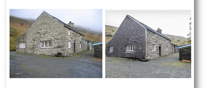
Situated in an exposed location in Snowdonia, the 16-century farmhouse at Dyffryn Mymbyr has regularly contended with extreme wind and rain and as a result, the walls on the exposed gable end of the building were becoming saturated. To protect it against the changing weather patterns, the end of the farmhouse has been covered with “slate hanging” a traditional approach for weatherproofing which will mitigate the effects of the increasingly stormy conditions.
Coastal erosion is a growing problem in Wales, with landslips becoming a frequent occurrence across the country. The village of Porthdinllaen lies on the Llŷn Peninsula coastline; its cultural and historic value is equally matched by its importance as a tourism destination. It is experiencing an increasing number of landslips, due to recurring storms and soft cliffs that sit behind the village. The rapidly rising sea levels present a constant threat and suggest that the cottages there could be uninhabitable within fifty years. To strengthen the village’s resilience to the changing climate, the charity is working with the local community to look at measures such as flood gates, flood doors and improved drainage systems to protect people’s homes.
National Trust Cymru is already taking action to try and respond to the threat posed by climate change, with ambitious tree planting and regeneration programmes, mitigating flooding by slowing the flow of rivers in Upper Conwy, restoring blanket bog on the upland commons to increase carbon storage, and working with partners and tenants to create species-rich grasslands across Wales.
Rebecca Williams, Assistant Director for National Trust Cymru said
“Understanding and adapting to climate change is one of the greatest challenges we will face in Wales over the next few years and we all have our part to play. The launch of this map provides new and valuable data that will allow us to take informed steps and achieve a positive impact.
This year is an important year for climate change, with COP26 in Glasgow, the G7 meeting in Cornwall, and Welsh Government’s recent renewed commitment to achieve net zero by 2050. The eyes of the world will be on the UK and how we are responding to the climate crisis we are facing.”
National Trust Cymru is already working in partnership with government bodies to plot all cultural heritage sites across Wales.
Dr Kate Roberts, Cadw’s Head of Historic Environment commented
“The impact of climate change, and in particular the extreme weather events that we are experiencing with increasing frequency, are one of the most significant threats facing our historic environment.
“Our actions today determine the historic environment that future generations will experience. Knowing how and where to focus our resources is challenging which is why research such as this is so critical.”