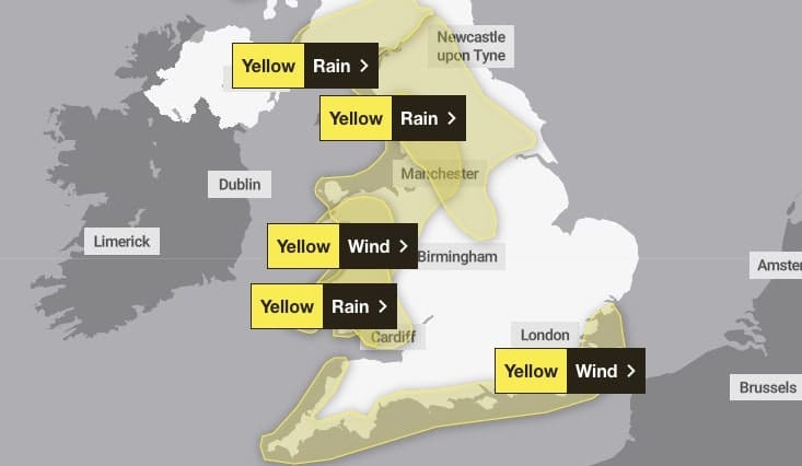
A brief spell of very windy conditions is likely through Wednesday evening and night, bringing the chance of some disruption.
During Wednesday evening and night, a further spell of very strong southwesterly winds is expected to sweep east to produce gusts of 50 to 60 mph.
There is also the potential for gusts of around 70-75 mph near exposed coasts and over high ground. Heavy, squally showers will accompany these strong winds. The winds will ease later in the night.
What should I do? Prepare to protect your property and people from injury.
Check for loose items outside your home and plan how you could secure them. Items include; bins, garden furniture, trampolines, tents, sheds and fences. Give yourself the best chance of avoiding delays by checking road conditions if driving, or bus and train timetables, amending your travel plans if necessary. People cope better with power cuts when they have prepared for them in advance. It’s easy to do; consider gathering torches and batteries, a mobile phone power pack and other essential items.
If you are on the coast, stay safe during stormy weather by being aware of large waves. Even from the shore large breaking waves can sweep you off your feet and out to sea.
Take care if walking near cliffs; know your route and keep dogs on a lead. In an emergency, call 999 and ask for the Coastguard.
Be prepared for weather warnings to change quickly. When a weather warning is issued, the Met Office recommends staying up to date with the weather forecast in your area.
What to expect
- There is a small chance of injuries from flying debris
- There is a slight chance of some damage to buildings, such as tiles blown from roofs
- Some delays to road, rail, air and ferry transport expected
- Delays for high-sided vehicles on exposed routes and bridges
- Some short term loss of power and other services
- Coastal routes, sea fronts and coastal communities will be affected by spray and/or large waves
Areas affected in Wales
- Bridgend
- Carmarthenshire
- Ceredigion
- Conwy
- Denbighshire
- Flintshire
- Gwynedd
- Isle of Anglesey
- Neath Port Talbot
- Pembrokeshire
- Powys
- Swansea
- Vale of Glamorgan
- Wrexham

