
The Met Office has issued an Amber warning as Storm Babet approaches and will bring disruptive rain and strong winds in the coming days.
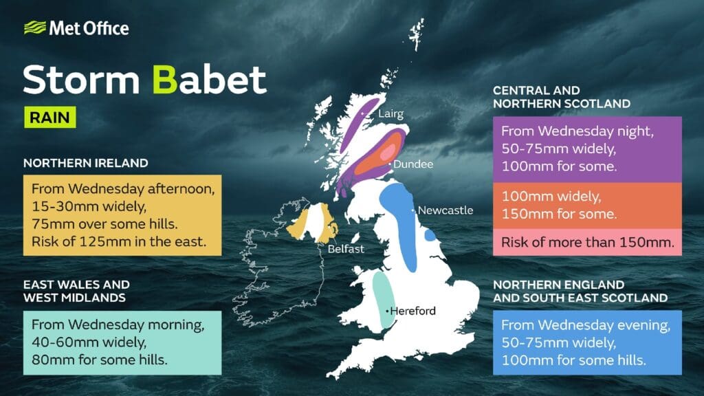
The influence of Storm Babet will begin to be felt late on Tuesday and into Wednesday as heavy and, in places, disruptive rainfall will move in from the south and west, impacting Northern Ireland and much of England and Wales.
As the rain moves northwards it will stall across central and eastern parts of Scotland where the rain will become heavy and persistent from Thursday through to Saturday. There is an Amber Severe Weather Warning for rain for this area where up to 150-200 mm of rain could accumulate in some areas of higher ground.
Strong southeasterly winds will also create dangerous conditions along the east coast of the UK, with large waves an additional hazard.
A number of weather warnings are in force for Storm Babet, with heavy rain also likely for Northern Ireland, as well as large parts of England and Scotland.
Met Office Deputy Chief Meteorologist Tony Wardle said: “Storm Babet will bring disruption for parts of the UK in the coming days, with heavy rain and strong winds likely for many.
“Heavy and persistent rain will fall onto already saturated ground bringing a risk of flooding. It is important to stay up to date with warnings from your local flood warning agency as well as the local authorities.
“As well as heavy rain, Storm Babet will bring some very strong winds and large waves near some eastern coasts too. Gusts around 70 mph are possible in eastern and northern Scotland from Thursday. Met Office warnings will continue to be reviewed as the forecast develops.”